Address: 4730 Crystal Springs Drive, Los Angeles
Phone: (323) 913-4688
Park features: Restrooms, Dogs On Leash, Easy Hiking, Equestrian, Mountain Biking, Picnic Tables, Parking Lot, Drinking Water, ADA Accessible
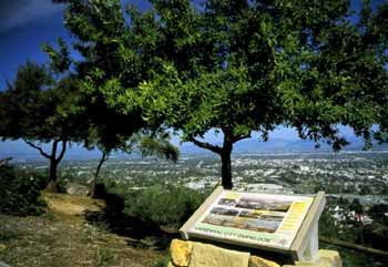
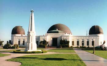
With over 4,107 acres of natural terrain covered with California oak trees, wild sage and manzanita, Griffith Park is the largest municipal park and urban wilderness area in the United States. Situated in the eastern Santa Monica Mountain range, the Park's elevations range from 384 to 1,625 feet above sea level with climates varying from semi-arid chaparral foothills to forested valleys. Over the years recreational attractions have been developed throughout the Park, however an amazingly large portion of the Park remains virtually unchanged from the days when Native American villages occupied the area's lower slopes. Today's Griffith Park offers numerous family attractions, an assortment of educational and cultural institutions, and miles of hiking and horseback riding trails. Originally a part of the Spanish land grant, Rancho Los Feliz, the park was named for its former owner, Colonel Griffith J. Griffith. Born in Glamorganshire, South Wales, Griffith emigrated to the United States in 1865, eventually making a personal fortune in California gold mine speculation. In 1882, Griffith settled in Los Angeles, and purchased a 4,071 acre portion of the Rancho Los Feliz, which stretched northward from the northern boundaries of the Pueblo de Los Angeles. On December 16, 1896, the civic-minded Griffith bequeathed 3,015 acres of his Rancho Los Feliz estate as a Christmas gift to the people of Los Angeles to be used as parkland. The enormous gift, equal to five square miles, was to be given to the city unconditionally – or almost so. "It must be made a place of recreation and rest for the masses, a resort for the rank and file, for the plain people," Griffith said on that occasion." I consider it my obligation to make Los Angeles a happier, cleaner, and finer city. I wish to pay my debt of duty in this way to the community in which I have prospered." Since Griffith's original gift, further donations of land, along with City purchases and the reversion of private land to public domain have expanded the Park to its present size. When Colonel Griffith died July 7, 1919, he left a sizeable trust fund to complete the dreams he had for the park; specifically designating funds for the construction of a Greek amphitheater (the Greek Theatre, built in 1930) and an observatory and hall of science (Griffith Observatory and Planetarium, built in 1935). Hours & Regulations: Griffith Park is open to the public from 6 a.m. to 10 p.m. daily. Bridle trails, hiking paths, and mountain roads are closed at sunset. The speed limit on all park roads is 25 mph and is strictly enforced. Brush fires present a definite safety hazard, especially from Spring to early Fall, when the natural chaparral and underbrush is very dry. Open fires are prohibited; barbecue pits are provided free of charge at picnic areas. In case of emergency in the park, notify the Ranger Station at (213) 913-4688 or dial 911. Directions: Griffith Park lies just west of the Golden State Freeway (I-5), roughly between Los Feliz Boulevard on the south and the Ventura Freeway (SR 134) on the north. Freeway off-ramps leading to the park from I-5 are Los Feliz Boulevard, Griffith Park (direct entry) and Zoo Drive. Approaching the park on SR 134 eastbound, take either the Forest Lawn Drive or Victory Boulevard offramps. From SR 134 westbound, take Zoo Drive or Forest Lawn Drive. After leaving freeways, follow the signs into the park.
Trails & hiking
Featured route: East Observatory Trail, Berlin Forest, and Mount Hollywood (trail details & live conditions on AllTrails)
- Distance: 4.7 mi (7.6 km) — Out & back
- Elevation gain: 1131 ft (345 m), high point 1624 ft
- Difficulty: Moderate
- Typical time: 2.5–3 hr
- Rating: 4.7/5 (931 AllTrails reviews)
- Good for: Hiking, Mountain biking, Trail running
- On the trail: Dogs on leash, Views, Wildflowers, Wildlife, Historic sites
Conditions vary by season. Check live weather and air quality on the AllTrails trail page before heading out.
Location
4730 Crystal Springs Drive, Los Angeles
Approximate coordinates: 34.1184, -118.3004
View on OpenStreetMap
Photos

Related documents
Nearby parks
Park description restored from the 2017 lamountains.com archive (Santa Monica Mountains Conservancy). Trail statistics courtesy of AllTrails. Map data © OpenStreetMap contributors.