Address: Near 13069 Victory Blvd.
Park features: Dogs On Leash, Easy Hiking, Mountain Biking, Picnic Tables, Parking Lot, ADA Accessible
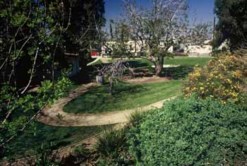
This is the first park of its kind along the Tujunga Wash flood control channel. The one mile segment of the once-natural Tujunga Wash includes walking paths, beautiful native landscaping, comfortable benches, interpretive displays, a meandering stream, views of the Santa Monica Mountains, and a shaded picnic area. In addition, this innovative project provides a natural solution for cleaning water that will eventually flow into the ocean while, at the same time, adding to the region's water supply. A gravity-fed pipe takes urban runoff from the flood control channel and creates a new stream with some of the natural characteristics of the once free-flowing Tujunga Wash. Native plants in the streambed help clean the water, and establish habitat for animals such as birds, frogs, and lizards. During a year with average rainfall, as much as 325,000 gallons of water will flow through the naturalized streambed and will produce enough groundwater recharge to provide 760 families of four with drinking water for an entire year. This recreational and ecological amenity can be replicated in neighborhoods throughout the 500 miles of open flood control channels in the County of Los Angeles.
Trails & hiking
Featured route: The Great Wall of Los Angeles: Tujunga Wash Path (trail details & live conditions on AllTrails)
- Distance: 4.5 mi (7.2 km) — Loop
- Elevation gain: 72 ft (22 m), high point 725 ft
- Difficulty: Easy
- Typical time: 1–1.5 hr
- Rating: 4.0/5 (149 AllTrails reviews)
- Good for: Road biking, Walking, Running
- On the trail: Dogs on leash, Kid-friendly, Stroller-friendly, Wheelchair-friendly, Partially paved, Rivers
Conditions vary by season. Check live weather and air quality on the AllTrails trail page before heading out.
Location
Photos


Photo credits: (1-3)
Nearby parks
Park description restored from the 2017 lamountains.com archive (Santa Monica Mountains Conservancy). Trail statistics courtesy of AllTrails. Map data © OpenStreetMap contributors.