The essential takeaway: The Palm Springs Aerial Tramway cuts 6,000 feet of elevation gain, letting hikers reach Mount San Jacinto’s 10,834-foot summit in a day. This strenuous 11-mile hike offers 360° alpine vistas and stark desert contrasts. Prioritize early starts, hydration, and layered clothing—**summit’s 30°F colder**. At 9,700 feet, a stone shelter signals the final scramble, balancing adventure and accessibility for determined hikers.
Craving a high-alpine escape without the grueling 10,000-foot climb?
The Mount San Jacinto hike from the Palm Springs Tramway slashes 6,000 feet of elevation gain, delivering jaw-dropping summit views in half the effort.
This isn’t just another desert trek—it’s a vertical leap from scorched desert to alpine wonderland, where pine-scented trails and 360° vistas of the Coachella Valley await.
As someone who’s navigated Andes peaks with toddlers in tow, I’ll show you how to conquer this iconic California summit responsibly, with insider tips on beating crowds, layering for sudden mountain storms, and why that tram ride itself might just be the most thrilling part of your journey.
- Your alpine escape begins: the Palm Springs Aerial Tramway
- A Step-By-Step Guide On The Trail To San Jacinto Peak
- Gearing Up: Your Essential Packing And Preparation Guide
- The Reward: From Alpine Forests To 360-Degree Summit Views
- Know Before You Go: Park Rules And Safety First
Your alpine escape begins: the Palm Springs Aerial Tramway
Picture this: one moment you’re surrounded by Palm Springs’ sun-baked sprawl, the next you’re soaring 2.5 miles as the desert shrinks beneath you.
The Palm Springs Aerial Tramway isn’t just a ride—it’s a front-row seat to nature’s grandest transformation. As the tram’s rotating floor turns, watch arid plains fade into pine forests and granite peaks. Even if heights make your stomach flutter, the 360° views of San Jacinto’s slopes are worth it.
This isn’t just elevation—it’s a climate shift. The air cools 30°F in 10 minutes, and the scent of Jeffrey pines replaces desert chaparral.
Arrive early—the first cable car departs at 8:00 AM (seasonal variations apply), offering cooler temps and empty trails. Book tickets online to avoid sold-out morning slots. Parking costs $15; gates open at 7:00 AM on weekends. Once aboard, brace for a 10-minute ascent that climbs nearly 6,000 feet, highlighted by seismic research sites tracking California’s tectonic shifts.
At Mountain Station (8,516 ft), grab a postcard or hot cocoa—your last chance for amenities before hitting the trail. Pro tip: The tram’s capacity is 80 people per gondola, so arrive by 8:30 AM for solitude.
This tramway is a game-changer.
By bypassing 6,000 feet of elevation gain, it turns a 20-mile sufferfest into an 11-mile alpine adventure.
Don’t underestimate the altitude—air at the summit holds 30% less oxygen than at sea level. Layer up: temperatures drop 30°F from valley to summit, and afternoon storms can roll in fast. Before hiking, grab a free wilderness permit from the ranger station’s kiosk. At Mountain Station, breathe crisp mountain air—a stark contrast to desert heat—and mentally map your route. Trails are well-marked, but keep an eye out for “Tram” signs guiding your return.
The tramway’s magic isn’t just vertical—it’s environmental and deeply personal.
As I learned hiking post-maternity leave, this is where California’s landscapes stop being a backdrop and become the whole story. Whether you’re chasing sunrise on the summit or a moment of clarity above the desert, this tramway delivers both altitude and perspective.
| Route | Starting Point | Round-trip Distance | Elevation Gain | Estimated Time | Difficulty |
|---|---|---|---|---|---|
| From the Tramway | Mountain Station (8,516 ft) | ~11 miles / 17.7 km | ~2,600 ft / 792 m | 5-7 hours | Strenuous |
| From Idyllwild | Marion Mountain or Deer Springs Trailhead | 16-18 miles / 25-29 km | ~4,500 ft+ / 1,370 m+ | 8-10 hours | Very Strenuous |
| Cactus to Clouds (C2C) | Palm Springs Museum Trail (~500 ft) | ~20 miles / 32 km | ~10,400 ft / 3,170 m | 12-16 hours | Extreme / Elite hikers only |
Mount San Jacinto’s trails offer wildly different experiences, but the Palm Springs Aerial Tramway route strikes the perfect balance between accessibility and adventure.
Starting at 8,516 feet bypasses 6,000 vertical feet of desert climbing while delivering 360° alpine panoramas. The 2.5-mile tram ride through chaparral to pine forests sets the stage—ideal for families or first-time high-altitude hikers seeking wildflowers in summer and snow-dusted pines in winter.
For those craving a true test, the Cactus to Clouds (C2C) route ranks among America’s most punishing day hikes.
This 21-mile gauntlet gains over 10,000 vertical feet—searing desert heat giving way to icy summit winds with temperature swings up to 75°F. A documented case notes a runner summited in 9 hours carrying 6 liters of water, crediting intense training. Even fit hikers face a stark truth: this route emphasizes mental resilience as much as physical strength.
The Idyllwild option, less extreme than C2C, still demands respect. Starting at 5,600 feet, hikers tackle Marion Mountain’s switchbacks or Deer Springs’ exposed ridgelines—quieter trails weaving through conifer forests with mule deer sightings. Extra mileage suits overnight trips best; overnight permits are required for Round Valley or Tamarack Valley, adding planning steps compared to the tram’s simplicity.
While all routes demand preparation, the tramway approach delivers the greatest reward-to-effort ratio.
You’ll tackle 2,600 feet of elevation through pine forests and alpine meadows without C2C’s existential risks. The final scramble near the summit—technical enough to excite—remains non-technical. For most adventurers, this is the San Jacinto experience: instant mountain access, epic views, and a tram ride home. Plus, shorter exposure to high-altitude ecosystems reduces environmental impact, aligning with eco-conscious travel.
A Step-By-Step Guide On The Trail To San Jacinto Peak
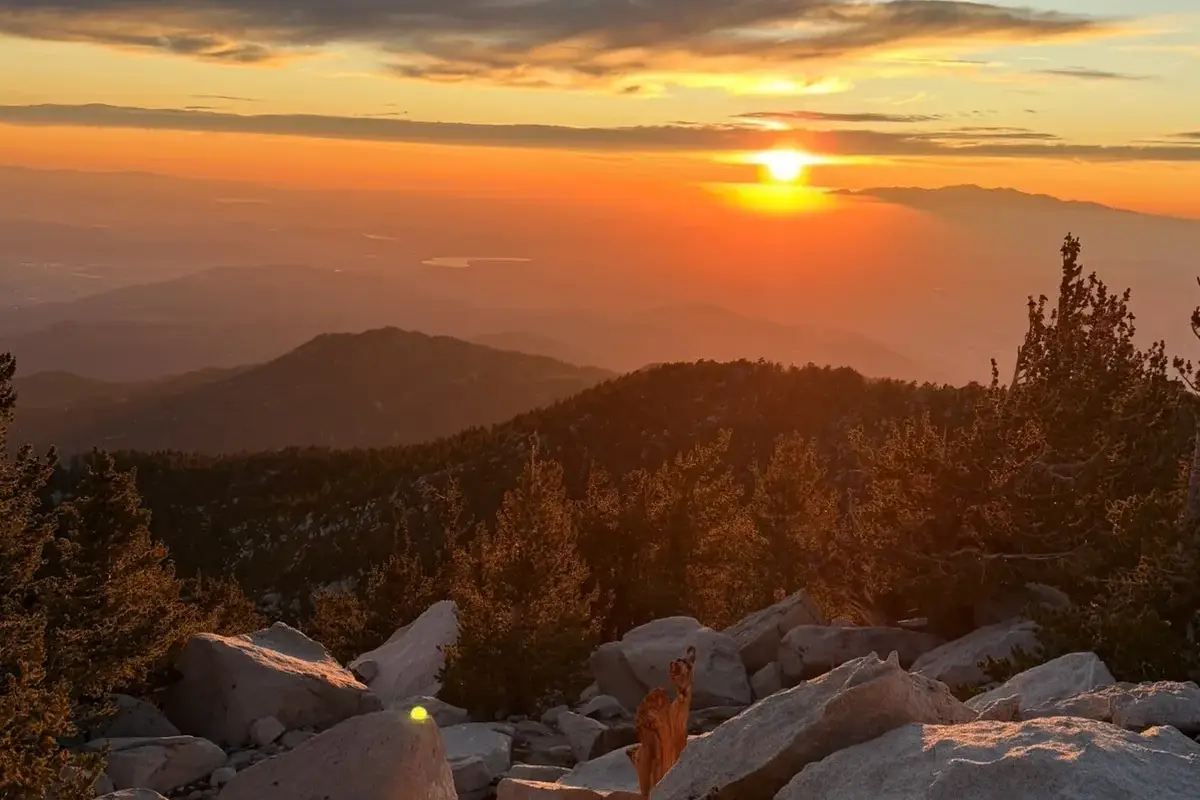
Stage 1: From The Mountain Station To The Ranger Station
Step out of the Palm Springs Aerial Tramway’s Mountain Station and immediately notice the crisp alpine air replacing the desert’s dry heat. The 0.4-mile paved path descends through a forest of white fir and lodgepole pine, where the only sounds are rustling leaves and the occasional call of a Clark’s nutcracker.
Watch for mule deer grazing in shaded clearings or quail darting across the trail. At the trailhead, locate the Long Valley Ranger Station, a humble wooden outpost tucked under the trees. Completing the self-issue wilderness permit isn’t just a bureaucratic formality—it’s your contribution to preserving this high-altitude haven. Rangers use permit data to track trail usage and allocate resources. Clip your copy to your pack for easy access. Pro tip: Start before 7 a.m. to avoid both the midday sun and tramway crowds spilling onto the trail.
Stage 2: From The Ranger Station To Wellman Divide
The Round Valley Trail begins with a gentle climb through silver-fir groves, their citrusy scent sharpened by altitude. At 1.5 miles, pass a seasonal spring where marmots and squirrels congregate—stop to watch their comically bold antics. By 2.5 miles, Round Valley (9,100 ft) emerges like a secret garden: meadows of paintbrush, lupine, and sky pilot (a rare alpine flower) bloom in summer, fed by snowmelt. Refill water here, but use a filter or purification tablets—this stream carries Giardia, a parasite that turns summits into stomachaches.
The trail narrows past Round Valley, threading between manzanita thickets and juniper that twist into wind-sculpted shapes.
At 3.3 miles, Wellman Divide (9,700 ft) delivers a panoramic punch: the Coachella Valley’s geometric agriculture sprawls below, while the San Jacinto crest towers ahead. Pause to adjust layers—starters at dawn may still wear fleeces, while midday hikers strip to moisture-wicking tops.
If nausea or dizziness hits, descend immediately. Altitude doesn’t care about your fitness level.
Stage 3: From Wellman Divide To The Summit
The final 2.2 miles demand technical focus. The trail disintegrates into loose granite slabs, requiring hand placements for stability. This is a Class 2 scramble—no ropes needed, but concentration is mandatory. At the last junction, follow a faded sign pointing left toward the summit. Cairns guide you up the range’s spine, where the air thins and every step feels heavier.
At 0.2 miles from the peak, the 1933 stone shelter cabin appears—a Depression-era relic built by the Civilian Conservation Corps. Inside, logbooks document hikers’ triumphs and emergencies. Stash extra gloves or energy bars for others. The final 0.1 miles expose you to wind-carved granite and infinite sky.
Scramble right to avoid the steepest rocks. Suddenly, the summit (10,834 ft) materializes. The Pacific shimmers 120 miles west; Mount San Gorgonio’s silhouette dominates the north. Savor the achievement, but move swiftly—storms can roll in within 30 minutes.
This hike isn’t just vertical—it’s a masterclass in contrasts. The tramway spares you 6,000 feet of desert climbing, but the summit demands grit. I’ve seen fit hikers falter here, unprepared for thin air. Pack 3 liters of water, start by 6 a.m. to beat heat and thunderstorms, and never skip the permit. On my last trip, I left a childproof snack in the shelter for a future hiker—a small act of solidarity in a place where self-reliance meets community. Now, lace up. The trail’s waiting, and the mountain doesn’t care how many summit selfies you’ve taken.
Gearing Up: Your Essential Packing And Preparation Guide
Mountains demand respect. Even with the tramway shortcut, your adventure starts at 8,516 feet—where altitude sickness risks begin. H
ydrate aggressively before boarding, and remember: rapid ascent to over 10,000 feet can trigger headaches or nausea. Pace yourself; the summit’s thin air rewards patience.
Weather lies at the valley floor. While Palm Springs bakes, summit temperatures routinely plunge 30°F colder.
Check mountain-specific forecasts—not valley readings. Winter snowfields and spring ice patches demand crampons; summer’s relentless sun requires sun protection. Pack layers: a breathable base, insulating mid-layer, and waterproof outer shell.
- Navigation: Paper map + compass or GPS device. Trails disappear under snow.
- Sun Protection: UV rays intensify with elevation. Pack SPF 50+ sunscreen and glacier glasses.
- Insulation: Fleece jacket, waterproof gloves, and a wool beanie save energy reserves.
- Illumination: Headlamp for early starts or unexpected delays.
- First Aid: Include blister care—your feet will thank you on rocky descents.
- Fire: Waterproof matches for emergencies.
- Repair Kit: Duct tape, multi-tool, and zip ties fix torn gear mid-hike.
- Nutrition: 500+ calorie snacks per hour. Trail mix with dried fruit and nuts fuels climbs.
- Hydration: 2-3 liters minimum. Treat Round Valley’s stream water with a filter.
- Emergency Shelter: A compact space blanket weighs nothing but saves lives.
Footwear matters. Sturdy hiking boots with ankle support prevent sprains on loose scree. Trekking poles? Non-negotiable. They reduce knee strain by 25% during rocky descents. I learned this hiking Peru’s Cordillera Blanca—my knees still thank me.
Never gamble with the elements. Check tramway closing times religiously—missing the last ride means a 6-mile night scramble down Chino Canyon. Carry a backup power bank for your phone; cell service dies above Round Valley. This isn’t just caution—it’s mountain wisdom earned through decades of guiding adventures across two continents.
The Reward: From Alpine Forests To 360-Degree Summit Views
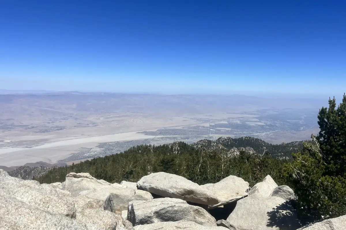
Stepping onto the trail from Mountain Station, the immediate shift from desert to alpine ecosystems feels almost magical. Lodgepole pines, incense cedars, and white firs form a fragrant canopy overhead, their needles crunching underfoot as the path winds through shaded groves. The contrast is stark: below, the sun-baked Coachella Valley stretches endlessly, while here, cool mountain air carries the scent of resin and earth. This isn’t just a hike—it’s a vertical journey through California’s ecological extremes.
Round Valley’s meadows burst with color in summer. Scarlet paintbrush, purple lupine, and golden sunflowers blanket the slopes, attracting hummingbirds and butterflies. I’ve always found these alpine blooms humbling—a reminder of nature’s resilience in such rugged terrain. Keep an eye out for mule deer grazing quietly or a coyote’s fleeting silhouette at dawn. Remember to observe wildlife from a distance; feeding animals disrupts their natural behaviors and risks harm to both parties.
At Wellman Divide, the final push begins. The trail narrows, switching back through granite boulders where pines cling defiantly to cracks in the rock. Here, the scale of the landscape humbles even seasoned hikers. As you crest the last ridge, the payoff materializes: a 360-degree panorama stretching from the San Gorgonio peaks to the Pacific’s distant shimmer. On clear days, the ocean glints faintly 80 miles west—a surreal sight from 10,834 feet.
The summit’s geodetic marker makes a perfect photo backdrop, but the real magic lies in the silence. Standing above it all, the desert’s relentless energy feels worlds away. I remember pausing here years ago, my breath short from altitude and exertion, struck by how this vantage point compresses California’s extremes into a single frame. It’s a moment that redefines “perspective.”
Descending later, I often reflect on why this hike resonates. It’s not just the physical challenge or the views—it’s the layered experience of moving through ecosystems, witnessing nature’s contrasts, and leaving only footprints. For those seeking a journey that rewards effort with raw, unfiltered beauty, Mount San Jacinto delivers a story etched in stone, sky, and memory.
Know Before You Go: Park Rules And Safety First
Mount San Jacinto isn’t just a hike—it’s a high-altitude adventure where preparation separates awe from risk. Safety and respect for this wilderness area are non-negotiable. The mountain’s dramatic elevation gain—from desert floor to alpine peak—demands both physical readiness and environmental awareness.
Mount San Jacinto State Park enforces strict rules to protect its fragile ecosystem. Dogs are banned—a rule that prevents wildlife disturbances and hiker conflicts. Follow Leave No Trace principles: this 2025 Leave No Trace Spotlight Initiative will host events like the February 2 trail cleanup at Bogert Trailhead to preserve these landscapes for future generations.
- Start early. Catch the first tram at 8 AM (or 10 AM Mon-Fri) to beat summer heat and afternoon storms. I learned this the hard way during a sudden 10,000ft hailstorm.
- Know your limits. Altitude affects everyone. I met a fit hiker who wisely turned back at Wellman Divide—smart decisions deserve applause.
- Check the last tram down. Missing the 9 PM (10 PM weekends) tram means a midnight trek. Round Valley’s campsites aren’t ideal after dark.
- Stay on the trail. Winter snow hides hazards. One group’s off-trail slip led to a 3-hour rescue—avoid becoming a statistic.
Winter transforms this hike into a serious challenge. When I summited in March, microspikes saved me on ice-glazed rocks. For gear advice, read SmarterSweat’s winter guide. Snowshoes work for powder, but crampons grip better on exposed ridges.
This isn’t a casual walk. Park Service reports 15+ annual rescues—most preventable with preparation. Carry extra water. Verify layers. Prioritize safety over summit fever: the real reward is returning safely to share the story. And remember, the tramway’s rotating floor offers 360° views—but the true magic happens when you respect nature’s terms.
“The Mount San Jacinto hike from Palm Springs Tramway transforms desert heat into alpine coolness. This trail’s stark contrasts, physical challenge, and panoramic summit views make every step worthwhile. Start early, pack smart, respect the mountain. Atop this SoCal peak, embrace challenges and cherish nature responsibly—some of life’s greatest rewards await.”
FAQ
What’s the distance of the hike from the Palm Springs Tramway to San Jacinto Peak?
This iconic hike spans approximately 10.1 to 11 miles (16.2-17.7 km) round-trip from the Mountain Station to the summit. Starting at 8,516 feet (2,596 m), you’ll gain 2,600 feet (792 m) to reach the 10,834-foot (3,302 m) peak. The trail is well-marked but includes rocky sections and a final scramble over boulders – nothing technical, but definitely a workout! I remember my first time tackling this trail with my older child watching from camp – every step felt like a lesson in perseverance.
How long should I plan for this Mount San Jacinto adventure?
Most hikers invest 5-7 hours round-trip, though I recommend allowing 8-9 hours to truly savor the journey. Your pace, weather conditions, and photo stops will influence timing. Start with the first tram at 8:30am to beat afternoon clouds and enjoy cooler temperatures. When I did this with a friend recovering from altitude sickness, we took our time and still made it back with an hour to spare before the last tram – proof that steady wins the race!
Is the Palm Springs Aerial Tramway a worthwhile experience for hikers?
100% yes! This engineering marvel transports you 6,000 vertical feet (1,829 m) in just 10 minutes while rotating for 360° views. As someone who’s ridden cable cars from the Andes to the Alps, this one stands out with its dramatic transition from desert to alpine climate. Pro tip: Take the 9am tram to beat crowds, and don’t miss the interpretive displays at Mountain Station – they’ll help you appreciate the ecological diversity you’ll witness on your hike.
What’s the best way to approach the Mount San Jacinto hike?
Start by securing your free backcountry permit at the Long Valley Ranger Station (0.4 miles from Mountain Station). Follow the clearly marked trail through pine forests and alpine meadows, using the “tram” markers on posts for navigation. At Wellman Divide (3.3 miles in), take a breather – those views of the Coachella Valley below and Mount Gorgonio in the distance deserve your full attention. The final 2.2-mile push to the summit includes that memorable boulder scramble. Don’t forget to check the stone shelter cabin built in 1933 – I always leave a token from home as a little pilgrimage.
Do I need any special permits for this hike?
For day hikers staying within the Long Valley area, no permits are required. If you’re going beyond (like to the summit), fill out a self-issue wilderness permit at the ranger station – it’s free and takes 2 minutes. This system protects the environment while ensuring safety. When I hiked with my husband, we treated the permit like our “passport” stamp – a small ritual marking our mountain journey.
What’s the exact mileage from tram station to peak?
The round-trip distance measures 10.1-11 miles (16.2-17.7 km) from the Mountain Station. The first 3.3 miles (5.3 km) to Wellman Divide gain 1,184 feet (361 m), with the final 2.2 miles (3.5 km) to the summit climbing another 1,134 feet (346 m). This isn’t just a number – it’s a journey through ecosystems! I particularly love how the trail transitions from lodgepole pines to rocky alpine terrain as you ascend.
Where exactly does the Palm Springs tramway take you?
This engineering marvel connects Palm Springs’ desert floor to the 8,516-foot (2,596 m) Mountain Station. You’ll travel 2.5 miles (4 km) through 5,873 feet (1,790 m) of vertical ascent – that’s like climbing 884 flights of stairs! From the station, you can access over 50 miles (80 km) of trails, including the path to San Jacinto’s summit. Pro eco-tip: The tram’s energy-efficient design reduces hiking-related emissions by eliminating 6,000 feet (1,829 m) of climbing.
How long does the tram ride itself last?
Those 10 memorable minutes will transport you from desert to alpine climate while rotating 360° for panoramic views. The ride covers 2.5 miles (4 km) with dramatic elevation gain – I always time it with sunrise for that magical first light on the mountains. Pro tip: Don’t rush off at the top! The tram’s schedule allows 10+ hours on the mountain even with the 8:30am boarding.
What elevation does the tram reach at its summit?
The Mountain Station sits at 8,516 feet (2,596 m), already higher than many Colorado 14ers! From here, the trail climbs another 2,318 feet (707 m) to San Jacinto’s 10,834-foot (3,302 m) summit – California’s second-highest peak south of the Sierra. That temperature difference? Expect 30°F (15°C) cooler at the top! When I hiked in August, we stashed our extra layers at the station’s lockers for the summit push.