Address: Pacific Coast Highway and Malibu Canyon Road
Phone: (310) 589-3200
Park features: Easy Hiking, City Views
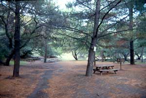
Overlooking the majestic Pacific Ocean, 84-acre Malibu Bluffs Open Space provides spectacular ocean views both up and down the coast, as well as views of the Santa Monica Mountains. A network of trails are ideal for jogging, hiking, and wildlife viewing beside coastal sage scrub, southern willow scrub, and open grasslands. Some trails lead from the bluffs downhill to Malibu Canyon Road with access to the wet sand on the beach. MTA bus stops are located on Malibu Canyon Road (both directions) approximately 1,000 feet north of the main park entrance at the intersection of Pacific Coast Highway and Malibu Canyon Road. Park entrances and public street parking are also located on Malibu Canyon Road south of the park. Malibu Bluffs Open Space is adjacent to, and west of, the City of Malibu-owned Malibu Bluffs Park. The City-owned park includes parking, baseball diamonds, and the Michael Landon Community Building, which provides restrooms and drinking fountains.
Trails & hiking
Featured route: Malibu Bluffs Park Loop (trail details & live conditions on AllTrails)
- Distance: 1.1 mi (1.8 km) — Loop
- Elevation gain: 36 ft (11 m), high point 79 ft
- Difficulty: Easy
- Typical time: 0.5–1 hr
- Rating: 4.6/5 (287 AllTrails reviews)
- Good for: Birding, Walking, Running
- On the trail: Dogs on leash, Kid-friendly, Beaches, Views, Wildlife
Conditions vary by season. Check live weather and air quality on the AllTrails trail page before heading out.
Location
Pacific Coast Highway and Malibu Canyon Road
Approximate coordinates: 34.0345, -118.685
View on OpenStreetMap
Photos


Photo credits: Judi Tamasi (1-4)
Nearby parks
Park description restored from the 2017 lamountains.com archive (Santa Monica Mountains Conservancy). Trail statistics courtesy of AllTrails. Map data © OpenStreetMap contributors.