
Address: 20825 Entrada Road, Topanga
Phone: (310) 454-8212
Park features: Restrooms, Easy Hiking, Equestrian, Mountain Biking, Picnic Tables, Parking Lot, Drinking Water, ADA Accessible
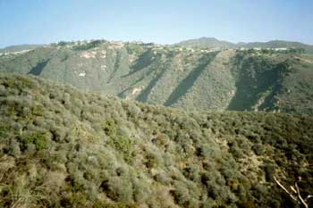
Located in the cliffs and canyons of the Santa Monica Mountains, Topanga State Park features 36 miles of trails through open grassland, live oaks and spectacular views of the Pacific Ocean. The park is located entirely within the Los Angeles city limits and is considered the world’s largest wildland within the boundaries of a major city. More than 11,000 acres of land are preserved in the park. Excellent recreational opportunities abound for hikers as well as mountain bikers (restricted to fire roads) and equestrians. The park is bound on the south by Pacific Palisades and Brentwood, on the west by Topanga Canyon, and on the east by Rustic Canyon. Numerous geologic formations can be found in the park, including earthquake faults, marine fossils, volcanic intrusions, and a wide variety of sedimentary formations. Park Trails Many of the park's trails can be accessed from Trippet Ranch. The Musch Trail leads north to Musch Trail Camp by winding in and out of the sun and shade where plant assemblages change with every subtle difference in light and moisture. Two miles from Trippet is Eagle Junction, where hikers encounter the Eagle Spring loop trail. Eagle Rock, one of the many boulder outcrops on the trail, looms over the terrain and provides panoramic views of the park. At the eastern end of the Eagle Spring loop, hikers will come to the Hub Junction and the Temescal Fire Road. Going north, hikers travel through chaparral to unpaved Mulholland Drive, which traverses the park. South on Temescal Fire Road takes hikers high above the wild canyons with sycamore and oak riparian forests below. At Rogers Junction, hikers can opt for the Backbone Trail, a trail that winds through the Santa Monica Mountains from Will Rogers State Historic park in the east to Point Mugu State Park in the west. Rustic Canyon can be seen from the Backbone Trail. Another option from Trippet Ranch is to walk east to the Topanga Fire Road and then north for a short distance to the Santa Inez Trail. Descending into the Santa Inez Canyon, hikers can see crumbly sandstone formations containing pockets where moisture can collect, supporting numerous small plants that form tiny cliff gardens. Close to the bottom of the trail is a side trail leading to a lovely waterfall. Directions: From Pacific Coast Highway, travel north on Topanga Canyon Boulevard, pass the post office at the center of "town," then turn right on Entrada Road. Keep to the left at every opportunity until you reach the park's main parking lot (about one mile). From the Ventura Freeway (101), exit at Topanga Canyon Boulevard, drive south over the crest of the mountains and proceed three miles to Entrada Road and turn left.
Trails & hiking
Featured route: Eagle Rock via East Topanga Fire Road (trail details & live conditions on AllTrails)
- Distance: 3.9 mi (6.3 km) — Out & back
- Elevation gain: 902 ft (275 m), high point 1919 ft
- Difficulty: Moderate
- Typical time: 2–2.5 hr
- Rating: 4.7/5 (1,412 AllTrails reviews)
- Good for: Hiking, Trail running
- On the trail: No dogs, Forests, Views, Wildflowers
Conditions vary by season. Check live weather and air quality on the AllTrails trail page before heading out.
Location
20825 Entrada Road, Topanga
Approximate coordinates: 34.0928, -118.5873
View on OpenStreetMap
Photos
Nearby parks
Park description restored from the 2017 lamountains.com archive (Santa Monica Mountains Conservancy). Trail statistics courtesy of AllTrails. Map data © OpenStreetMap contributors.

