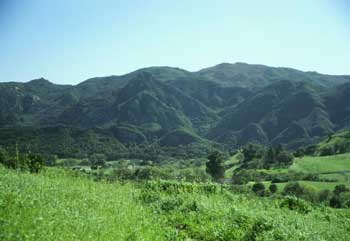
The Backbone Trail runs 67 miles across the spine of the Santa Monica Mountains, from Will Rogers State Historic Park in Pacific Palisades to La Jolla Valley at Point Mugu. It is the only continuous trail of its kind in the Greater Los Angeles area and the only one anywhere that lets you walk from a downtown-adjacent neighborhood to a remote oceanfront wilderness without leaving public land.
The trail was assembled in pieces over forty years. The last segment, Etz Meloy Motorway, was acquired and opened in 2016, which is when the Backbone became a true end-to-end route. For nine years it ran clean. The January 2025 Palisades Fire then cut the eastern third in half, and recovery has been section by section. This is the working 2026 picture.
A short history
The idea of a single coast-spine trail goes back to the 1970s. The Santa Monica Mountains National Recreation Area was created by Congress in 1978 with explicit instructions to build it. The route was negotiated parcel by parcel over the next thirty-five years, mostly by the NPS and the Santa Monica Mountains Conservancy, sometimes by eminent domain, often by deal-making with private landowners. Etz Meloy was the last holdout. When that 1.7-mile easement closed in 2016 the trail finally connected.
The Backbone is mostly single-track and fire-road. A handful of segments cross paved roads at canyon crossings (Encinal, Kanan Dume, Latigo, Las Virgenes). The trail crosses three California State Parks (Topanga, Malibu Creek, Point Mugu) and weaves through NPS, MRCA and county land in between. There is no continuous permit for thru-hiking. There are two trailside camps: Musch Trail Camp in Topanga State Park and the walk-in La Jolla Valley camp at Point Mugu.
The 2026 post-Palisades picture
The Palisades Fire burned through the eastern Santa Monica Mountains in January 2025. Will Rogers, where the trail starts, reopened November 8, 2025 with the Inspiration Point Loop and the upper Bone Canyon Road accessible. The West Inspiration Loop and the Lower Betty Rogers Trail are still closed, which affects the very first mile of the Backbone. Most of Topanga State Park reopened by late 2025. The MRCA-managed Topanga-area parcels (Ed Edelman, Tuna Canyon, Top of Topanga Overlook, Mill Creek, Red Rock Canyon) remain closed and may stay closed through 2026.
Malibu Creek State Park is back open daily 8 a.m. to 10 p.m., with the M*A*S*H site bridge reinstalled in April 2026. Castro Crest is the awkward middle: the trail is technically open, but Upper Corral Canyon Road that gets you to the trailhead has been closed since late 2024 for road repairs. The western half of the trail, from Kanan Dume onward, was outside the burn perimeter and is fully open.
If you want to do a thru-hike in 2026, the cleanest version starts at Saddle Peak (the eastern edge of Malibu Creek SP) and ends at Point Mugu. Forty-five miles, all clean, no closures.
The trail, east to west
Section 1: Will Rogers to Trippet Ranch (Topanga SP)
About 6 miles. Starting at the Inspiration Point trailhead, the Backbone climbs onto the spine and contours into Topanga State Park, dropping into Trippet Ranch. Strong views of Santa Ynez Canyon, the Pacific, and the lower Palisades on a clear day. Post-fire, the trail surface is uneven in patches and several lookouts are signed for active recovery. Strongly suggest doing this section as a Will Rogers out-and-back rather than the through-route until the Topanga MRCA parcels reopen.
Section 2: Trippet Ranch to Saddle Peak via Hondo / Hub Junction
About 7 miles. This is the highest sustained ridge walk on the eastern half. Saddle Peak summit (2,805 ft) gives the cleanest 360° in the eastern range. The Hub Junction in upper Topanga is the traditional pivot for half-day hikers coming up from Will Rogers, Trippet Ranch or the Topanga town parking. Open in 2026.
Section 3: Saddle Peak to Piuma Road / Malibu Creek SP
About 6 miles. The trail drops off Saddle Peak through Stunt Road and Piuma into the Malibu Creek watershed. Crosses the upper Mesa Peak grade. Connects to the Malibu Creek State Park network and the Rock Pool / M*A*S*H trail system. This is the section most people do as a day-hike when they want the meatier Backbone experience without the Sandstone Peak climb. Open.
Section 4: Malibu Creek SP to Latigo Canyon via Castro Crest
About 8 miles. The trail climbs over the Castro Crest ridge through the Castro Crest trailhead area and drops into Latigo Canyon. The trail itself is technically open. The Castro Crest trailhead parking via Upper Corral Canyon Road is closed, which means the standard out-and-back from the upper lot is currently unreachable by car. If you are thru-hiking, you walk through. If you are section-hiking, this is the most painful piece to plan around in 2026. Most section-hikers skip it and rejoin at Latigo or Kanan Dume.
Section 5: Latigo to Kanan Dume to Newton Canyon
About 6 miles. Clean fire road and single-track through the central Malibu canyons. Newton Canyon Falls (small, seasonal) is on this section. The Kanan Dume Road crossing is the most accessible roadside trailhead on the whole Backbone, which makes this segment a common starting point for car-camp loop hikes. Open.
Section 6: Newton Canyon to Yerba Buena via Etz Meloy
About 8 miles. Etz Meloy Motorway is the segment that was missing until 2016. The trail traverses the highest country of the Encinal-Yerba Buena watershed before dropping toward the Yerba Buena trailhead and the Circle X area. Big ridge views, sparse shade. Open.
Section 7: Circle X Ranch (Sandstone Peak) to Danielson Ranch (Rancho Sierra Vista)
About 8 miles. This is the high point in every sense. From Circle X Ranch the trail climbs to Sandstone Peak (3,111 ft, the highest summit in the range) and then drops into the Boney Mountain wilderness on the way to Danielson Ranch and Rancho Sierra Vista / Satwiwa. The Mishe Mokwa side trail is the alternate approach to Sandstone Peak that most weekend hikers know. Open.
Section 8: Rancho Sierra Vista to Mugu Peak / La Jolla Valley
About 8 miles. The Backbone descends from Satwiwa into Big Sycamore Canyon and ends at the La Jolla Valley walk-in camp with Mugu Peak (1,266 ft) above it and the Pacific 1,200 feet below. La Jolla Valley is the only piece of native California bunchgrass left intact in the entire range. The terminus is the official western endpoint of the Backbone. Open.
Logistics
The Backbone is not a wilderness trail and is not a wilderness experience. It crosses paved roads, public lots, residential ridges and an active state park or two. That makes the logistics easier than a real backcountry thru-hike but more frustrating than they should be.
Water: scarce. Will Rogers, Topanga SP, Malibu Creek SP and Circle X have potable taps. The middle sections (Castro Crest, Etz Meloy) have nothing. Plan three liters per day minimum and refill at the parks.
Camping: there are two trailside camps. Musch Trail Camp in Topanga State Park (reservation required through California State Parks) and La Jolla Valley walk-in camp at Point Mugu. There is no stealth camping along the rest of the trail and rangers actively patrol the developed sections.
Transportation: the trail is point-to-point with no through-shuttle. Section hikers use trailhead parking at Will Rogers, Trippet Ranch, Stunt Road, Latigo, Kanan Dume, Yerba Buena, Circle X and Rancho Sierra Vista. A full thru-hike requires a car shuttle, an Uber back to the start, or a sympathetic friend.
Best season: November through May. June and the marine layer give you cool cloudy hiking on the western half and hot inland sections on the eastern half. July through October is fire-season hot and there are regular red-flag closure days. Avoid August entirely if you can.
If you are not going to thru-hike
Most people do not thru-hike the Backbone. They section-hike it, and most of the section-hike traffic concentrates on five day-hikes:
Will Rogers Inspiration Point to Eagle Rock in Topanga, roughly 7 miles round-trip. The classic eastern preview. Constrained right now by the still-closed Topanga parcels but doable as a Will Rogers loop.
Trippet Ranch to Eagle Rock and the Hub, 6 miles round-trip. Cleanest Topanga Backbone day-hike. Trippet Ranch parking is $10.
Mishe Mokwa to Sandstone Peak loop from Circle X, 7.2 miles. If you only do one Backbone segment in your life, do this one. Highest summit in the range, best view in the range.
Danielson Ranch to Boney Mountain summit, 8.5 miles round-trip. Strenuous, far less crowded than Sandstone. The hike I send people on when I want them to see what the western Backbone really feels like.
La Jolla Valley camp loop to Mugu Peak, 4 miles. The terminus walk. Bunchgrass valley, ocean drop, and the satisfying feeling of standing at the end of the only true coast-spine trail in the country.
What makes it different
The Backbone is not the prettiest long trail in California. Pacific Crest people will tell you it is not even close. What it is is unique: an end-to-end ridge route across the only large coastal range that sits inside a major American city. You can finish the trail at La Jolla Valley, look out at the Pacific, and from the same overlook see the freeway you parked next to in Pacific Palisades five days earlier. There is no other trail like that in the country. Worth doing once if you live here.